Wednesday, May 8, 2013

Post 36

Today was beautiful. Right now it is 65 degrees and cloudy, the high today was 78 almost 80! Tonight is a high of 53 with 60% of precipitation.
The current temps right now are in the 60s. That is wonderful I can't believe it got up to the high 70s today when we had snow last week, ah well this is WI. Summer Weather!

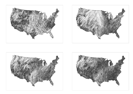
This is the current surface map as you can see there is a high right above us and its pushing some rain toward us as well.
 

This is the current wind map. Not a lot of movement over WI area but high gusts are seen in the west. 

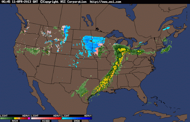
The Precipitation map shows us that we have/will be getting rain but not to too too much. 

Tuesday, May 7, 2013

Post 35

Today the weather looks nice. It is 55 right now with a high
of 77 today.
Today's surface map is clear a high front in Canada and lots of rain coming for the east. top


An invisible, ancient source of energy surrounds us—energy that powered the first explorations of the world, and that may be a key to the future. This map shows you the delicate tracery of wind flowing over the US.

Donate to Hurricane Sandy relief efforts here.

NEW: wind map prints are available from Point.B Studio.

Read more about wind and about wind power.


The wind map is a personal art project, not associated with any company. We've done our best to make this as accurate as possible, but can't make any guarantees about the correctness of the data or our software. Please do not use the map or its data to fly a plane, sail a boat, or fight wildfires :-)

If the map is missing or seems slow, we recommend the latest Chrome browser.

Surface wind data comes from the National Digital Forecast Database. These are near-term forecasts, revised once per hour. So what you're seeing is a living portrait. (See the NDFD site for precise details; our timestamp shows time of download.) And for those of you chasing top wind speed, note that maximum speed may occur over lakes or just offshore.

If you're looking for a weather map, or just want more detail on the weather today, see these more traditional maps of temperature and wind.

HINT.FM.


Post 34

The weather today looks really nice a high of 77! And right now its 56.
According to this surface map, we are looking at clear skies for a while.

There is a high up in Canada, and it looks like the East will get some rain however the Midwest and especially WI look clear for now.

This map shows the dew points for the nation. condensation occurs when the temperature of the air is lowered to its dew point. And seeing that these dew points are less then the temp we should be fine for rain, as of today.

Tuesday, April 30, 2013

Post 32

Today the high was  81 degrees! As you can see from this surface map there is a lot going on in the nation. There is a low pressure system cutting through WI and a little rain in the Milwaukee area. 

On this map you can see the omega high we will be jumping into. when this cold monster pushes southward, I expect to see severe weather areas throughout the Great Plains and the western parts of the Southeast. Over the course of 2 days, locations between Houston to Mobile will see temperatures drop from the mid to high 80’s on Wednesday to the low 70’s by Friday.  Yes, it is a significant drop, but looking at the Eau Claire area, the temperature will be near 75 today and only 40 tomorrow


Monday, April 29, 2013

Post 31

Today the high was 75 degrees! The frist map shows the clouds moving over MN and into WI they are not freezing the temp of the clouds is moderatly cold.
This is the current surface map for today. the cold front is leaving and the warm front is sneaking in.
We don't seem to have any problems on our Doppler radar as of right now. The only main problem I see is in Iowa and the serve rain there.
This map lays out our current wind conditions. there are light winds near the Milwaukee area but not too much that we in Eau Claire have to worry about.

Sunday, April 28, 2013

Post 30

Today there was a high of 74! As you can see on this Doppler radar there is rain coming into WI from MN. There is a lot of rain in the east as well.
This Water vapor satellite shows us the rain and the coverage of water vapor in the nation. Just as a review: Water vapor is water in its gaseous state-instead of liquid or solid (ice). Water vapor is totally invisible. If you see a cloud, fog, or mist, these are all liquid water, not water vapor. 

As for the surface map, there is a high associated with the rain in upper WI and that will move down as the rain comes in. 

Wednesday, April 24, 2013

Post 29

Today was a high of 52 degrees!
As you can see there is a front coming in from MN to WI.
There is a little rain on the current surface map but it shouldn't last long.


 The water vapor map is very interactive today. Because it was so warm and there was a lot of evaporation it increased the water vapor.


This map shows the drought severity. WI is very moist and not in a drought warning, we actually just left a flood warming.

Tuesday, April 23, 2013

Post 28

The weather today was colder then yesterday! The front really cooled it down. 


The current meteorological situation seems very similar to what we saw last week, but there are some major exceptions.  We have a frontal boundary from Wisconsin to Nebraska, holding back some very cold air. 

This current surface map was collected early in the morning. 


As you can see later at night is when this surface map was collected the front moved through the state.

This shows the front on the Doppler radar map. It was not serve rain but it was a lot of rain. 


Monday, April 22, 2013

Post 27


North Central US Current Temps
How to read this map   Severe Weather Outlook Free Content    National Forecast Free Content
As you can see from the temp map, it was 46 in la crosse and it was a high of 45 today and rainy hopefully- knock on wood that is the break in temp and we will start getting warmer temps.  
It was overcast all day and rainy at the end of the day. It is also getting colder, and may snow later tonight. 


As we can see in the doppler radar map rain and snow is coming our way. 


This shows the record highs and lows. In 1980 the record high was 90 degrees and the record low was 19 a few days ago we could of tied this low. 


Sunday, April 21, 2013

Post 26

Today the high is 44 and it was snowing a bit and over cast for the majority of the day.


Dew poins for today Eau claire/ La Crosse area is at 44. Both the dew point and the temp matched today which means that the air is heavily saturated. precipitation is at hand (it did snow) As a review: The dew point is a water-to-air saturation temperature.


This map shows the wind direction and wind speed today. This is being measured at the 500 millabar height and WI is sailing in about -24. 

Saturday, April 20, 2013

Post 25

Today has been beautiful! Not a could in the sky, clear, blue, and beautiful.
It is 42 degrees right now with wind gusted coming in at 10mph, from the northwest.


This map from NOAA Shows the wind speed and direction along with highs and lows of the day. There is a cold front running through Wisconsin, in this map.


Here we have the highs and lows of the day. 
The high in La crosse area is 41 and our high is 42. It was a wonderful day today. First day of real spring, knock on wood.


Friday, April 19, 2013

Post 24

The weather today has been crazy!

The clouds are moving so fast and they all have their own personaltiy! snow one mintue then sun then windyyy then over cast then blizzard then sunny then rain it's been a day full of weather whiplash.


The map depict the current radar situation and the national forecast for today.  There may be some severe weather in the Southeast, but there is a lot of snow that continues in Wisconsin and Minnesota.


Monday, April 15, 2013

Post 23

We are having some crazy weather!

This just in Yogi bring snow storms and major wind to the rockies.
We are in a flood weather watch. 

It’s going to be a strange week of weather…just another example of the weird things going on in the atmosphere over the past few years.


We see another cold front cutting through the Midwest, from Wisconsin to Texas and this is going to dominate weather over the Southeast for the next week.

By the way, the name of the winter storm moving through Minnesota and Wisconsin is named “Yogi”, and there is a small area of Low pressure following close behind.


Crazy, weird, and wacky are the words that come to mind when I see this. There is some serve weather happening in the nation in the next few days. 


Post 22

Tis the season for winter storms! the next one up is yogi and it is expected to bring 8-13 inches at its highest point.

Thursday, April 11, 2013

Post 21

In the past 2 hours it has rained, hailed, sleeted, snowed then rained again and now it is snowing. There was a winter weather advisory that came into effect yesterday that told us we were expected to recieve 8-12 inches of snow!
So if  April showers bring May flowers then what does April snowfalls bring?

We are looking at flood warnings for the Eau Claire area And a new Winter storm Walda.

We are looking at a lot of percipitation coming our way.


There is nothing on the surface map for WI right now but there is a lot off to the left of WI in MN and I have a feeling that will hit us hard. 


Tuesday, April 9, 2013

Post 20

Weather thunderstorms! rain! hail! Mother nature can't decide what to give us.


The frontal system that stretches across the northern part of our country is creating a real mess for the Upper Midwest.  The current radar and temperature charts show the dramatic change in the weather over portions of the Rocky Mountains and northern tier states. 

Monday, April 8, 2013

Post 19

As this map shows us, there is snow, rain and hail storms in WI. I think its funny when the meteorologists mention that there will be a wintery mix but that is truly what is going to happen. 


The high today was around 40 degrees. To have a proper 'Wintery mix' the temp must be cool enough for snow and warm enough for rain, which mean the low 40s. 

This is the surface map for our nation. As you can see in WI there is rain. We are also surrounded by low fronts in MN and IL. 

Sunday, April 7, 2013

Post 18

The weather today was overcast then really sunny! raining tonight and 50 degrees tomorrow!!


This screen shot shows a low front moving through IL connecting to a high up near Canada. 

This will be the nicest day out of the next several days. There is also a high coming from Canada which will break up the clouds and make the day a little more enjoyable. 


As we can see here there is rain on the way along with a low/high front moving in for cooler temps. 


Wednesday, April 3, 2013

post 17

The weather today was very nice. Right now it is 36 degrees with zero precipitation! About time. It was generally sunny and breezy today. We had 52% humidity and winds coming from the South.


The surface map shows that there is a high on the boarder of WI and MN. As a review: High pressure areas are normally caused by a phenomenon called subsidence, meaning that as the air in the high cools it becomes denser and moves toward the ground. We could be looking at clear skies for a while! 


Wednesday, March 27, 2013

post 16

The weather today was very over cast in the morning with temperature around high 20's. The could
cover looked like nimbostratus/altostratus. This cleared out and the sun came out warming it to 45 degrees! It was beautiful. It was in the 30s all day and the wind was coming from the west most of the day.    

Wednesday, March 13, 2013

Post 15

I am happy to report that there were baby blue skies today and I believe that means atmospheric stability. It was a very nice 30 degrees today. We had winds about northwest at 13 mph.
There is a chance that it could snow tomorrow. In that case there will be nimbus clouds in the sky. 
It will also make for a chilly spring break in WI. 

Tuesday, March 12, 2013

Post 14

This weekend we had crazy weather! On Friday it rained and snowed and rained then snowed! There are pictures of the clouds up that I took, and the snowy conditions. On Sunday morning at 3am it started snowing and at 8am there was already an inch on our cars. And it was icy! 

The clouds that produced such weather this weekend were Nimbostratus and Cumulonimbus- there were no thunderstorms but there was such a large storm that i belief both clouds were in the making of the weather. 

Today was a high of 29 degrees. Snow fall with Nimbostratus clouds and it was mostly cloudy. The wind direction was at North - North west at 10 mph. The humidity was 68%. And either rummor or Weather.com says it will continue to snow.     
 

Monday, March 4, 2013

Post 13

Post 13 very unlucky! We are in yet another winter storm watch! we had just a beautiful weekend with blue skies and high cirrus clouds. Today was super cloudy and no sun - we had altocirrus clouds moving into stratus according to your email. We have bad weather coming that is for sure, and it already started snowing! It is 10:15pm on monday night. 

Todays weather was pretty chilly in comparison to the nice day we had Saturday and Sunday. Todays high was 26 degrees at 6pm - thats pretty late to have the highest temperature  of the day but it seemed to be about 23 degrees around 3pm and it was snowy. The snow flakes were pretty big too, they looked like big soap clusters. 

There are south east winds coming in at 7mph right now and a low visibility. There is 54% humidity and a 15 degree dew point according to Weather.com. In the next couple hours it will be 25 degrees with winds 5-10 mph. Perfect for a snow storm. 

Wednesday, February 20, 2013

Post 12

Today was also cold. A high of 19 degrees and a lot of sun. Right now, according to Weather.com it is -8 degrees, partly cloudy with a north east wind  and humidity at 77%.  Tomorrow should be a high of 25 degrees with 10% precipitation. We are bracing ourselves for winter storm Q- as it should start to snow tomorrow night.


As you can see in this screen shot there is a high coming towards Eau Claire, WI with in the next 24-48 hours that should scare the snow away for a while and make the temp a little warmer.

Tuesday, February 19, 2013

Post 11

The weather today was COLD! Today's high was 17 degrees. there was a north west wind at 10 mph today and it made it feel like -15 with the wind chill. Right now it is -8 degrees with out the wind chill and we are looking forward to winter storm Q which should hit WI and give us anywhere from 3-12 inches of snow about Thursday.

Monday, February 18, 2013

Post 10

Today the high was 36 degrees. One of the highest temperatures we have seen lately. It snowed around 3pm today and is still going even at 11:30pm. it was very windy today. The wind was coming from the north west. According to Weather.com the temperature right now is 3 degrees and it feels like -15 with the wind chill. It is expected to get up to 17 degrees tonight and tomorrow we are looking at 7 degrees and snow.

Wednesday, February 13, 2013

Post 9

Today! it was warm 35! There was a West southwest wind and it started to snow at night. There was about 90% humidity.  As you can see in the map above it looks as thought it will continue snowing all throughout the night. Right now according to weather.com there is a 30% Dew point 93% humidity and an east northeast wind thats blowing at 5 mph. It is 32 degrees. I think tomorrow it will be around 30 degrees again, and hopefully sunny.

Tuesday, February 12, 2013

Post 8

It was so nice today! I am sure a majority of Eau Claire was excited and relived about just hitting the mid 30s today. It was beautiful and sunny. There was a west southwest wind blowing as well. Tomorrow it will continue to be beautiful with a hopeful high of 35 degrees and fingers crossed no snow.

Monday, February 11, 2013

Post 7

The weather today was warmer although it was wet. There was a lot of precipitation over the weekend. There was a lot of rain. (at least in the Platteville area) Maybe I brought the rain back with me, maybe not. The high today was 36 degrees. The wind came from the west at 12 miles per hour. And humidity was about 74%. This is all according to Weather.com

This map from NOAA shows that there is a low front in upper WI and the wind patterns wrap around the whole nations according to the high and low fronts.  
This map is more detailed on where exactly the front are located. It gives wind speed, direction, precipitation patterns and shows that the low is over the upper WI area.